I just got to edit and upload the slides and screencast of my talk at campusparty europe, so here you go: Campusparty are live streaming and recording the talks. Here is mine but sadly enough there is quite a chunk of audio missing and it seems To be out of sync later on. I also [...]
this, is planet bluesmoon
![[philiptellis]](https://en.gravatar.com/avatar/a96c9331b6ebb3aa112aa7b5e9dad912?s=64&r=g)
Saturday, August 25, 2012
 PHD Comics
08/24/12 PHD comic: 'Ph.Detours Ep. 1 - LAVA!!'
| Piled Higher & Deeper by Jorge Cham |
www.phdcomics.com
|
|
 |
||
|
title:
"Ph.Detours Ep. 1 - LAVA!!" - originally published
8/24/2012
For the latest news in PHD Comics, CLICK HERE! |
||


Thursday, August 23, 2012
 Anna Filina
Unveiling ConFoo 2013
The next ConFoo will be held on February 25 through March 1.
If you have never heard of ConFoo, it is one of the most important developer-oriented conferences. The team brings you speakers from around the globe to share their hands-on experience with various web technologies. The best news is: it’s driven by the community and

Wednesday, August 22, 2012
 Atul Chitnis
Things don’t always work out…
I regret to announce that for various reasons, we have had to cancel the workshop on the 25th of August. We have already initiated full refund of workshop fees to all registered attendees, and it will be processed within the next 48 hours. The reason for the cancellation is both bad timing and technical: What [...]
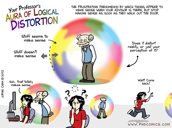
PHD Comics
08/20/12 PHD comic: 'The Aura'
| Piled Higher & Deeper by Jorge Cham |
www.phdcomics.com
|
|
 |
||
|
title:
"The Aura" - originally published
8/20/2012
For the latest news in PHD Comics, CLICK HERE! |
||


Tuesday, August 21, 2012
 Robert Nyman
Geek Meet September 2012 with Jonathan Snook
Sold out All seats have been taken. Please write a comment to be put on a waiting list, there are always a number of cancellations, so there’s still a chance. Time for another Geek Meet! If you’re not in Stockholm, you should make it here! Introducing Jonathan Snook I’ve known Jonathan Snook for many years, [...]

Monday, August 20, 2012
 Christian Heilmann
Being a better web citizen: complain where things get fixed
We like to complain. It feels good, it feels like we are doing something that will make things better. The problem is though, if we don’t complain where things can be changed we are not making things better. In a lot of cases we make them worse. In almost all cases where we don’t complain [...]
Derick Rethans
Derick's MongoDB tour
Derick's MongoDB tour
London, UK
Monday, August 20th 2012, 09:12 BST
It has been a while since I have written anything. In the last few months I have been busy rewriting the connection handling parts of the MongoDB driver for PHP. The next post will go deeper into that, and what else will be new in version 1.2 of the driver. Anyway.
Some time ago, my friend Ligaya Turmelle suggested that I should come and talk at the JaxPHP/JaxWeb, the PHP and web developers usergroup in Jacksonville, Florida. And while I was there, why not visit a few other user groups too?
At all the meetups, 10gen (my employer) has kindly provided some swag - and rumours go that I get to buy you guys and girls a drink as well.
In the end, after discussing with other web/PHP usergroups in the South East of the US, we came to the following schedule:

Boca Raton, Florida - SoFloPHP - Tuesday, September 18
The first stop is the South Florida group (SoFloPHP`) in Boca Raton. On the evening of the 18th, I will introduce MongoDB for PHP developers:
This talk introduces MongoDB for developers who aren't familiar with it with a detailed introduction of how to work with MongoDB from PHP. The talk will cover the basics from installing the PHP driver and connecting to mongoDB to creating, inserting, querying for, and updating documents. We will also briefly touch on aggregation, geospatial indexes, GridFS and running database commands.
I will focus on schema design and indexes, although I will also quickly cover the basics.
Orlando, Florida - The Orlando PHP User Group - Wednesday, September 19
After South Florida I will be making a stop at the Orlando PHP User Group. The abstract:
This talk introduces MongoDB for developers who aren't familiar with it through a detailed introduction of how to work with MongoDB from PHP. Derick will cover the basics: from installing the PHP driver and connecting to a MongoDB server to creating, inserting, querying, and updating documents. He'll also cover some accepted best practices in schema design and indexing.
There is also a related MongoDB event in Orlando, on September 6th there is an evening with MongoDB.
Jacksonville, Floria - JaxPHP/JaxWeb - Thursday, September 20
The third stop is in Jacksonville. In Jacksonville, the presentation will not be very PHP specific, and members of other user groups are most welcome to attend as well. You can RSVP at http://mongodb-jax.eventbrite.com/, and more information is available on the JaxPHP/JaxWeb website.
As other user groups are invited as well, I will keep my presentation as language agnostic as possible, and focus on schema design and indexing.
Atlanta, Georgia - Atlanta PHP User Group - Friday, September 21
I then leave Florida and head to Atlanta to talk at the Atlanta PHP User Group. In Atlanta, I will give a similar presentation as at the other user groups.
Nashville, Tennessee - Nashville PHP User Group - Monday, September 24
In Nashville, I will speak after the weekend at the Nashville PHP User Group. In this location, my talk focusses on:
Derick will be giving an introductory presentation covering the do's and don'ts, best practices and design schemas for MongoDB.
Holiday!
After the five user group appearences, I head to the North West of the USA for some R&R - after three weeks on the road (I speak at PFCongres before traveling to the USA) - I think I will need one!


Sunday, August 19, 2012
Gopal Vijayaraghavan
The Dog Days are Over
Friday was my last day in Zynga.
Zynga has been a very different place for me to work in. Coming from Yahoo, where the tech folks had sway over the company, to a place where the product managers were the core of the company was jarring to say the least. But adapting to thrive, indeed succeed there has polished off a few rough edges that I had.
I've sat at the cliff's edge between what's management and the frontline. I've stared into the abyss and stared it down. I've seen exactly how incentives work and more importantly, when incentives tend to work against you. I've learnt to temper my competitive spirit to skip the usual pitfalls of meritocracy. I've understood how to work with people who are not engineers.
I've known the difference between talking & persuading. To effectively bring people over to your side of the debate - whether it is with statistics or merely by running experiments. In some sense this is more diplomacy than being technically right every time - but there's no value in actually being wrong. And I got better at saying No.
I've learnt what risk looks like. Very early in this "game", I learnt to play offense. To gauge a risk, take it and occasionally clean up afterwards if it blew up in my face. And in some sense that's the general motto around there. I became quicker at churning out a solution, battle testing it and minor setbacks weren't really a deterrant anymore. And I was brave.
I got to treat crisises differently. I was on the on-call rota. Instead of panicking and hyperventilating, I started treating them as merely opportunities to offer solutions. And in my spare time, I prepared for these crisises which turned out to be massively productive moments of innovation. I tried to get some of it opensourced, but a lot of it is locked up in the paperwork that I never finished.
I've had my moments of frustration too. There have been scenarios which were charged with egos and people politics, which are probably no different in any other workplace - people trying to play schedule chicken, folks trying to delay others with scope creep, territorial engineers telling me to keep off their turf & avoidable meetings where people duel with power point slides full of promises they can't keep. I've occasionally gotten demoralized about all that, but I've managed to move beyond that and build out a stronghold around me.
And finally, the best thing that's happened to me was working with the senior technical folks in the Bangalore office. People like Binu, Prashun, Prakash & Jayesh have been a big part of my development at Zynga. And not just them actually, the whole team is full of fun folks who don't really consider work as the end-all of their daily life.
It felt like I was part of an uber startup!
--The world hates change, yet it is the only thing that has brought progress.
-- Charles Kettering

 Tarique Sani
Twitter Weekly Updates for 2012-08-19
Posted in Twitter Digests
Sounds very interesting http://t.co/iHzxgZ88 #GetGlueHD #TheSkinILiveIn # Faved On Flickr iPhoneography Showcase, 08.12.12 http://t.co/Pvt4aWF7 # This giant 3D printer can construct a house in as little as 20 hours http://t.co/v6Zu9nxN better than printing guns I guess # 10 handy jQuery mobile tips and snippets to get you started http://t.co/ClYJ5EXQ # Firefox Addons For Penetration Testing [...]Saturday, August 18, 2012

Blogroll
-
Anand Kishore
-
Anant Narayanan
-
-
Ara Pehlivanian
-
Arnab Nandi
-
Atul Chitnis
-
Ayttm
-
-
-
Dilbert
-
-
-
Jace
-
Jeremy Zawodny
-
Kartik Mistry
-
-
-
-
-
-
-
Rasmus Lerdorf
-
-
Satya
-
Sergey Chernyshev
-
ShowSlow
-
-
Shyam Mani
-
-
-
Stoyan Stefanov
-
-
Tahir Hashmi
-
-
Tom Croucher
-
Vijay Ramachandran
-
Vinayak Hegde
-
Vivek Nallur
-
Vivek Nallur
-
XKCD
-
-
Last updated: 20:00 UTC
Powered by:
![]()